
Weekly Report Ending 06th May & Forecast 07th To 13TH May 2017
This weekly weather report is for the period from 30th April 2017 to 6th May 2017. Forecast is provided for coming week from 07th to 13th May 2017.
The significance of this week was thunderstorm and rainfall activity for last few days in parts of South Konkan, Madhya Maharashtra and Vidarbha.
Reason For Thunderstorm and Rainfall activity
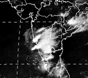
On 6th May, there existed a low pressure circulation over Central Madhya Pradesh which shifted to Northwest parts of Madhya Pradesh and a trough was running from this low pressure to North Interior Karnataka across Vidarbha and Marathawada as shown in figure below.
In the satellite image below of 22:30 IST shows the cloud bands due to the trough mentioned above. Under its effect there was thunderstorm activity over Madhya Maharashtra, Vidharba and rainfall over South Konkan, Madhya Maharashtra on 04th and rainfall at one or two places over South Madhya Maharashtra on 05th.
Under its effect rainfall recorded over many places in Maharashtra during 4th to 6th May 2017 as shown below:
Rainfall Recorded:
| RAINFALL WAS RECORDED IN MILIMETERS (MM) THIS WEEK IN DISTRICTS OF MAHARASHTRA: | |||
| 03rd May | R/F | 04th May | R/F |
| Vita | 41.0 | Ajra | 28.0 |
| Kolhapur | 13.0 | Radhanagari | 22.0 |
| Shahuwadi | 13.0 | Kankavli | 12.9 |
| K.Mahakal | 8.5 | Hatkangale | 12.0 |
| Tasgaon | 8.0 | Kudal | 11.0 |
| Radhanagari | 7.0 | Sangli | 9.0 |
| Gaganbawada | 6.0 | Miraj | 9.0 |
| Satara | 3.4 | Gaganbavada | 8.0 |
| Solapur | 3.2 | Changad | 8.0 |
| Panhala | 3.0 | Sawantwadi | 7.0 |
| Islampur | 2.0 | Patan | 4.5 |
| Shirala | 2.0 | Shahuwadi | 4.0 |
| Atpadi | 2.0 | Karmala | 3.0 |
| Osmanabad | 0.8 | Vaibhavwadi | 2.0 |
| Udgir | 0.5 | Harnai | 2.0 |
| Shirala | 2.0 | ||
| Mahableshwar | 1.2 | ||
| Akkalkot | 1.0 | ||
| Satara | 0.6 | ||
| Kolhapur | 0.4 | ||
| 05th May | R/F | 06th May | R/F |
| Sangli | 4.4 | Panaji | 10.2 |
| Solapur | 6.0 | Kolhapur | 10.0 |
| Mahableshwar | 5.0 | Vengurla | 4.4 |
| Kolhapur | 0.5 | Sangli | 1.5 |
Thunderstorm Activity:
- On 6th May thunderstorm occurred at number of places and on 30th April and 05th May at one or two places over districts of Madhya Maharashtra.
- On 02nd and 04th May thunderstorm occured at one or two places over Vidarbha.
- On 30th May Vidarbha also noticed dust storm activity at one or two places.
Temperature over Maharashtra
In Vidarbha on 30th April Bramhapuri recorded 44.5 deg C , Chandrapur 45.2 deg C on 05th and 45.8 deg C on 06th were the highest maximum temperature in India.
No heat wave observed over Maharashtra, Goa and Gujarat state. However maximum temperature were normal upto 02nd May and above normal from 03rd to 06th over Maharashtra state. Only Madhya Maharashtra was appreciably above normal on 06th May.
Mumbai Temperature from 05th May it was 34 deg C and on 1st to 4th it was 33 deg C and 34 deg C respectively. Though Mumbai temperatures were normal but there was discomfort due to high humidity.
Forecast for Next Week (From 7th May to 13th May)
Next week maximum temperature will be above normal upto 10th May. After 10th May there will be fall in maximum temperature over Gujarat state, Goa and Maharashtra excluding Vidarbha. Vidarbha will continue to be warm but heat wave condition will not prevail.
South Konkan – Goa will face thunderstorm on 07th May and from 10th to 13th May as North Interior Karnataka cyclonic circulation will supply the moist air. Temperature of South Konkan will be above normal from 10th to 13th May. In this activity Kolhapur district will also experience thunderstorm.
North Konkan and Gujarat state will be dry full week because Northwesterly wind over the area. Chances of thunderstorm over Vidarbha also is very rare because moisture feeding is not there due to northerly or northwesterly wind. Dust storm may occur in first half of the week.
Thunderstorm activity over Central Peninsular India, Central plateau of India is a common phenomenon. In our state it is Madhya Maharashtra, Marathwada and Vidarbha. Thunder activity occur over India in pre-monsoon and post monsoon season as the sun crosses over the equator twice. Sometime after break monsoon also thunderstorm activity occurs if the break is long and hot.