WEEKLY WEATHER & MONSOON REPORT DATED 02ND JULY 2017

Realised Weather over Maharashtra, Goa and Gujarat State. (25th June 2017 to 01st July 2017)
Weather Summary:
From the beginning of the week monsoon was pouring rain over South Gujarat and North Konkan area. On 27th monsoon was active over Vidarbha. But South Madhya Maharashtra Marathwada received less rain. Gujarat state got very good rainfall in the second half of the week.
SIGNIFICANT RAINFALL RECORDED IN MAHARASHTRA FROM 25TH JUNE TO 1ST JULY 2017:
- Talasari – 469 mm, Wada – 368 mm, Vikramgad 324 mm in Raigad districts on 25th June
- Pen – 396 mm, Karjat 238 mm, Roha 233 mm in Raigad districts on 29th June.
- Jawahar – 415 mm on 02nd July.
Monsoon Advancement last week:
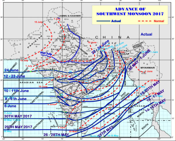
North Limit of Monsoon on 1st July 2017
- On 26th June monsoon advanced over some more part of north Arabian sea, Saurashtra and Kutch, most part of Gujarat region and some more parts of Madhya Pradesh.
- On 27th it further advanced into remaining parts of north Arabian sea, Saurashtra and Kutch, some more parts of Madhya Pradesh, some parts of South Rajasthan.
- On 01stJuly SW monsoon further advanced in to remaining part of Bihar most part of Madhya Pradesh and Uttar Pradesh and some more part of Rajasthan many part of Uttarakhand Himachal Pradesh and Jammu & Kashmir.
- NLM (Northern Limit of Monsoon) passes through latitude 26 degree N, longitude 70 degree E, Barmer, Kota, Gwalior, Bareli Mukteshwar, Dharamshala, Baderwah, Pahalgam, latitude 35 degree N and longitude 74 degree E.
Rainfall activity over Gujarat Region
Specially south Gujarat region got heavy to very heavy rainfall. The reason for this rainfall was formation of cyclonic circulation over south Gujarat coast on 26th June. This is a very common development in the monsoon advancement season.
The Position of East-West Trough
The east-west trough position played a vital role in giving rainfall distribution (shown in picture below). The east-west trough is same as monsoon trough. But since the monsoon is not set all over India, it is called as east-west trough.
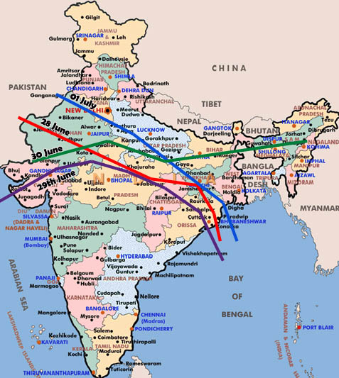 Trough line positions on different days
On 25th , 26th June and 27th June, the east-west trough was from West Rajasthan to East Central Bay of Bengal across North MP, Chhattisgarh, Jharkhand.
On 28th eastern part moved to West Central Bay of Bengal.
On 29th Western part also moved south wards and it run from centre of low over Kutch to WC Bay of Bengal.
On 30th the eastern part again moved to northwards to east Assam.
Finally on 01st the trough is from North West Rajasthan to North West Bay of Bengal across East UP , Bihar Jharkhand Gangetic West Bengal.
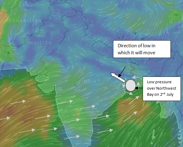
Offshore trough was from South Gujarat to Kerala coast throughout the week. One more system which gave slight help to our region was cyclonic circulation over North Odisha which moved north ward up to Bihar. On 30thJune a new cyclonic circulation developed over North West and adjoining West Central Bay of Bengal off south Odisha and North AP coast.
Forecast for Next Week:
As the cyclonic circulation over Northwest and adjoining West central Bay of Bengal moving north westerly direction the Maharashtra and Gujarat has no scope of getting much rain.
- In the first half of the week, north Konkan and South Gujarat will experience moderate to heavy rain but in second half only light to moderate rain.
- North and South Madhya Maharashtra will observe cloudy or light rain condition full week.
- Marathwada and Vidarbha will have sunny day or partly cloudy days.
- Kutch will experience sunny day full week and Saurashtra will experience either cloudy or light rain during the week.
- Condition of North Gujarat region also like cloudy or sunny days.
Note on Monsoon watch
System which has developed over North West and adjoining West Central Bay of Bengal is fruit full for North West India. It will advance the monsoon to North West India that is Punjab and North West Rajasthan. Also it will move from east UP towards west and giving monsoon rain to northern part of central India. (shown in picture below).
The other part of the country will not observe any monsoon like season.
A new system which will be forming on 09thwill help again to central India and central west India as it will be entering from Telangana. Otherwise next week will be dry for peninsular India. This time circulation over North West Bay of Bengal.