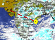
A cyclonic circulation over south east Bay of Bengal will become low pressure area and subsequently it will become more marked. Around 9th November this more marked low
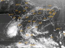
A Cyclonic Circulation lies over Bay of Bengal off North Tamil Nadu coast.North East monsoon active over peninsular India. Western disturbance affecting Punjab, Jammu & Kashmir, Himachal Pradesh
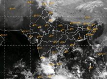
SouthWest Monsoon has withdrawn from entire country. North-East monsoon active over peninsular India. Western disturbance affecting Uttarakhand , West Uttar Pradesh, Himachal Pradesh and Haryana for coming two
Weather Forecast for the week 20th September to 26th September. A low Pressure Area lies over east Rajasthan and adjoining west MP. A cyclonic circulation lies over north
Weather Forecast for the week 06th September to 12th September Monsoon trough lies south of its normal position. A Low Pressure Area has formed over Bay of Bengal
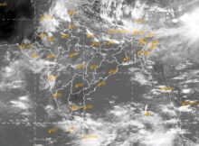
On 29th August 2021, a low-pressure area lies over West Central Bay of Bengal off South Odisha North Andhra Pradesh coast. Due to this system monsoon trough will
Monsoon trough is North of its normal position. It will further shift northwards. Rainfall activity will increase over North East India, Northern part of UP, Uttarakhand, Himachal Pradesh.
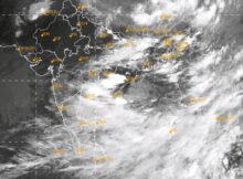
Western end of monsoon trough is close to foot hills of Himalaya. A cyclonic circulation lies over west Central Bay of Bengal off South Odisha coast. This cyclonic
Low pressure area is lying over North Madhya Pradesh. A weak off shore trough is seen from Karnataka coast to Kerala coast. This situation will give relief to
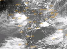
Weekly forecast for the week 19 – 25 July 2021: Monsoon trough is North of its normal position. Offshore trough is from Maharashtra coast to Karnataka coast. Cyclonic