Weekly Weather &Monsoon Report dated 25th June 2017

REALISED WEATHER OVER MAHARASHTRA, GOA AND GUJARAT STATE (18th to 24th JUNE 2017)
During the last week monsoon did not advance from 17th June to 20 June. Due to no significant weather systems there was decrease in the monsoon activity of India. Only North East states got good rainfall.
Monsoon Advance:
- On 21st June south west monsoon advanced into some more parts of Vidarbha.
- On 22nd June it further advanced into remaining part of Chhattisgarh and some more parts of Vidarbha.
- On 24th June monsoon further advanced in to some more parts of North Arabian sea, some parts of Saurashtra, some more parts of Gujarat region, remaining part of Madhya Maharashtra, Marathwada and Vidarbha. Now monsoon covers whole of Maharashtra.
As mentioned above the monsoon on 24th June 2017 was advance due to formation of circulation over Northwest Bay which increased the rainfall activity as shown in picture below:
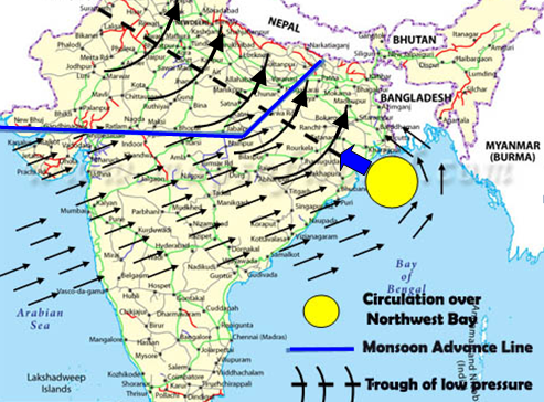
(Fig. 1)
Below is the NLM & it’s picture till 24th June 2017:
Northern Limit of Monsoon (NLM) passes through Latitude 22 N, Longitude 60 E, Latitude 22 N Latitude 22 N and Longitude 65 E Dwarka, Vallabh Vidya Nagari, Khandava Betul Mandla Patna Latitude 27 N and Longitude 85 E on 24 June.
(Click on below image to enlarge)
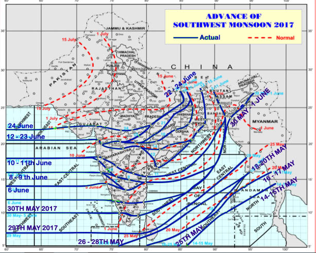
Northern Limit of Monsoon 24th June 2017 Source: IMD
Conditions are favourable for further advancement:
The activity of monsoon is controlled by one of the weather system known as Trough.
On 20th June the trough came to its normal position and monsoon became active over India. Click here to read how the positions of trough affects the monsoon over India.
When trough is south of its normal position, monsoon will be active over central India. If the trough is north of its normal position then monsoon is active over foothills of Himalaya & North East states. The same phenomena was seen during last week.
From 20th to 24th the trough was from west Rajasthan to North West Bay of Bengal and an upper air cyclonic circulation formed over coastal Odisha which moved to North West Bay of Bengal and intensified. (As shown in the Fig. 1 above) Now it seems that the same circulation will intensified into a low pressure area. From 24th monsoon became active over west coast also and it is entering in to Gujarat.
Forecast for next week:
- Konkan – Goa including South Gujarat region will experience heavy rain full week.
- From 28th onward North Gujarat region also experience heavy rain till that cloudy or partly cloudy condition.
- North and South Madhya Maharashtra will observe cloudy weather up to 28th and latter light rain will occur over the same area.
- More or less same situation is for Marathwada.
- Districs of Vidarbha will get heavy rain on 28th and 29th June rest of the days either cloudy weather or light rain will occur.
- Districts of North Gujarat will not be getting rain like South Gujarat. There will be cloudy weather up to 28th June and light to moderate rain thereafter.
- South Gujarat will experience heavy rain from 28th June to 01st July.
- Saurashtra will have cloudy weather up to 28th and there after moderate rain.
- Kutch will experience sunny day in the first half of the week and light to moderate rain in second half of the week.
- The low forming over North West Bay of Bengal seems to adopt the normal path of trough and it will give rain to MP, East Rajasthan and North Gujarat.
Note on Monsoon watch:
South-West monsoon was not active over west coast as told in our last bulletin. The reason was the low formed over north Bangaladesh which shifted the trough north ward. Whenever the trough moved northward the rainfall activity over India get slow down.
Now the low forming over North West Bay of Bengal seems to adopt the normal path of trough and it will give rain to MP, East Rajasthan and North Gujarat. This situation is a very common in monsoon season it should have happened with earlier low also but unfortunately it moved to North East States pulling the trough to northern side. Such a case gives a break spell. So coming days are good for central India and North West India. Only West Rajasthan will have to wait.
Click here to read how the positions of trough affects the monsoon over India.