WEATHER REPORT FROM 07TH TO 13TH SEPTEMBER & FORECAST FOR 14TH-20TH SEPTEMBER 2020

In last week the monsoon trough was located to the north of its normal position and mostly to the foothills of the Himalayas.
The monsoon was active throughout the week in Kerala, parts of Karnataka, along the Sub Himalayan region, Northeast parts such as Sikkim, Assam. In the later part of the week it was active in Nagaland, Mizoram, Manipur, Tripura, Madhya Maharashtra.
A low pressure was formed over Westcentral Bay of Bengal near Andhra coast in the morning of 13th Sept 2020.
Significant rainfall in the past week reported in mms:
7 Sept – Thiruvananthapuram 107, Gangtok 54, Ranchi 53, Aurangabad 54
8 Sept – Gangtok 41, Jaipur 37,
9 Sept – Thiruvananthapuram 107, Ranchi 58, Aurangabad, Gangatok 54 each.
10 Sept – Benguluru 63 Thiruvananthapuram 54
11 Sept – Mangaluru 258
12 Sept – Panjim 42, Pune 38
13 Sept – Bhuj 54, Panjim 52
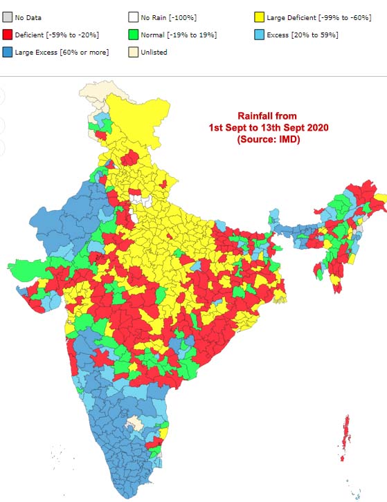
Rainfall from 01st to 13th Sept 2020. Information source: IMD.
Forecast
A low pressure formed on 13th over west-central Bay of Bengal near Andhra coast will become more marked on 14th September. It will move in the Northwest direction and later will become less significant by 17th September.
Rainfall activity will be seen and increased throughout the week in Andaman Nicobar Islands, Sub Himalayan region, in the state of Sikkim, Maharashtra, Andhra Pradesh, Telangana, Karnataka and Kerala.
Northwest parts of India showing the withdrawal symptoms due to less rainfall activity and the presence of anticyclonic winds.