WEATHER REPORT FROM 31ST TO 06TH SEPTEMBER & FORECAST FOR 07TH-13TH SEPTEMBER 2020
Weather Summary for Last week starting from 31st August to 06th September 2020:
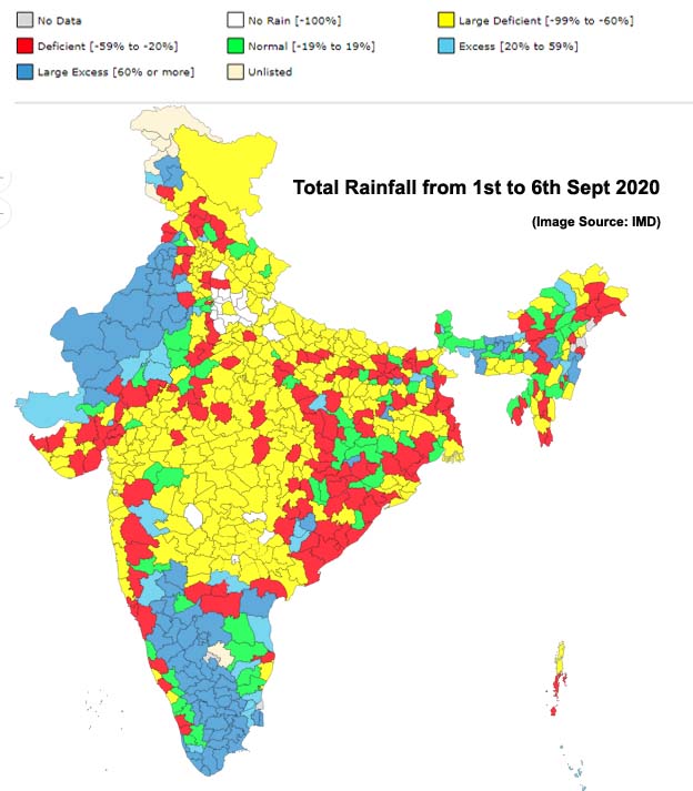
Most parts of India except for West and Northwest parts of Rajasthan and Peninsular parts had rainfall more than normal. Rainfall was below normal and well deficient at the rest of the places.
The less activity of rainfall was due to the Monsoon trough lying to foothills of Himalayas in the first part of the week then shifted little southwards but remained to the north of it’s normal position. (Read about Monsoon trough positions).
Low Pressure
The significant development was the formation of low pressure over South-east & adjoining East-central Arabian Sea on 6th September 2020.
In the beginning of the week on 31st August & -1st September a low pressure was lying over Northwest Rajasthan which had travelled west passing through Bay and central parts of India. Due to this Northwest parts had received good rainfall.
Monsoon activity:
Monsoon was active in some parts of Northwest, Northeast and Peninsular India.

Rainfall from 1st to 6th September 2020. Image Source: IMD
Significant rainfall recorded at 0830 hrs IST on respective dates:
31st August – Rajkot – 189 mm, Ahmedabad 44 mm
1st Sept – Ahmedabad 46 mm
2nd Sept – Vishakhapatnam 96 mm
3rd Sept – Indore 73 mm
4th Sept – Jaipur 25 mm
5th Sept – Jodhpur 53 mm
6th Sept – Minicoy 57 mm
Forecast for next week starting from 07th September to 13th September 2020:
The low formed over East Central Arabian will weaken by 8th September 2020.
A low-pressure system is likely to form over West Central Bay at the end coming week around 13th September 2020.
Monsoon trough likely to remain north of it’s normal position. (Read about Monsoon trough positions).